The Marine Odyssey
Seabeds: Between Ecological Wealth, Biodiversity, and Human Pressures
🌊🐚🌿🐠🪸
![]()
By Aurore Wermeille
The seabed — between ecological richness, biodiversity and human pressures Silent, mysterious, inaccessible… The seabed is as fascinating as it is elusive. And with good reason: the ocean floor remains one of the least explored areas on our planet. Around 80% of its surface has yet to be mapped using modern techniques, according to the Seabed 2030 [1][2]. Yet this invisible world is rich in unsuspected riches. Marine sediments are home to an abundance of life: bacteria, benthic invertebrates, bottom-dwelling fish… So many organisms that play a key role in the planet’s major biogeochemical cycles.
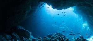
The seabed performs vital functions. They regulate the climate, store carbon, support entire food chains, and are home to exceptional biodiversity. However, behind their apparent silence, they are the discreet – and often invisible – witnesses of growing human pressure.
Certain marine regions, such as the Mediterranean, concentrate significant biodiversity: between 4% and 18% of the world’s marine species are recorded there, covering less than 1% of the ocean’s surface [3]. Others, like the North Sea, have been profoundly transformed. Dredging, bottom trawling, oil drilling: these environments bear the marks of decades of intensive exploitation.
And that’s not all. Another muffled sound emanates from the depths: that of construction machinery gradually nibbling away at coastal areas. Ports, dykes, quays, platforms… The race to develop the coastline is gradually – and often irreversibly – artificializing marine habitats.
Among these developments, port extensions are emblematic of an economic growth that is increasingly clashes with ecological limits. At the crossroads of maritime, logistical, ecological and social challenges, they raise a crucial question: how can port development be reconciled with preservation of the seabed?
At Sayari, we put science at the service of decision-making by combining life cycle analysis (LCA) and biodiversity expertise to assess the real impacts of these developments. In this article, we invite you to dive beneath the surface to better understand the ecological challenges linked to port extensions, through a concrete case study.
Two ports, two seas, two ecological realities
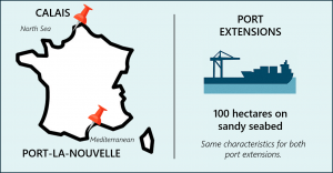
Let’s imagine two identical port extension projects in terms of area — 100 hectares — but located in radically different marine contexts: one in Calais, on the shores of the North Sea, the other in Port-La-Nouvelle, on the shores of the Mediterranean. Same surface area, same logistical ambition, but very contrasting ecological impacts.
Figures that speak for themselves
The results for our case studies are measured in PDF (Potential Disappeared Fraction of species), which is a richness indicator that assesses the risk of species extinction due to disturbance, such as port expansion in our case. This indicator estimates the probability that some of the species present in an ecosystem are threatened with extinction, depending on the intensity of the pressures exerted on that ecosystem. To find out more about the metrics used to measure biodiversity loss, click here.
📍The local scale, which quantifies the loss of species from a specific site in a given ecoregion.
🌍The global scale, which estimates the potential loss of global and irreversible species generated by port expansion.
For more details on these scales, click here.
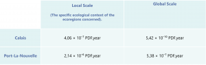
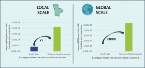
👉For the same surface area, the port extension at Port-La-Nouvelle has an impact on local biodiversity around 5 times greater than that at Calais.
👉The overall impact of the Mediterranean extension is almost 1,000 times higher than that of the North Sea extension.
These figures remind how much the ecological context of each area influences the consequences of our projects on global biodiversity.
Why such differences?
The results show a considerable difference between the impacts of the two projects, at both local and global scales. To fully understand these differences, we need to look at the ecological and methodological specifics of each level of assessment.
📍 On a local scale : the site’s history matters
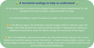
At this scale, we are not only concerned with what happens on the 100 hectares in question, but with the cumulative effect of a project in a given ecological context: that of the ecoregion, which refers to a coherent ecological area (such as the western Mediterranean or the southern North Sea).
| CALAIS – North Sea
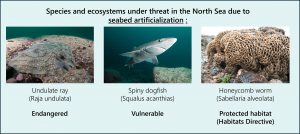
Calais is located in a maritime region that has been transformed by human activity for several decades. The topography is relatively homogeneous, with flat seabeds mostly made up of sand and gravel. These soft substrates have already been heavily altered by dredging, bottom trawling, aggregate extraction, and oil infrastructure [4][5]. In this already impoverished context, a new port extension disrupts a system that has already lost much of its initial biodiversity. Its marginal impact is therefore relatively low at this scale. |
|
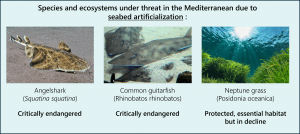
PORT-LA-NOUVELLE – Mediterranean Port-La-Nouvelle is part of a much more preserved and contrasting ecoregion. The seabeds are more varied: seagrass meadows, rocky areas, submarine canyons… This topographical complexity creates a great diversity of microhabitats, refuges for sensitive species, some of which are endemic. Furthermore, the conservation status of the area is still relatively good. Therefore, new artificialization represents a sudden disruption in a system that is still rich and fragile [6]. fdjghsgfjhkshksdfh fdsf |
🧭 What local impact measures is not just physical destruction, but the severity of this destruction in a given ecological context.
🌍 On a global scale : global biodiversity loss in focus
At this level, the analysis changes focus. The indicator seeks to estimate the extent to which a project contributes to the global disappearance of species. Here, the surface area affected or the initial state of degradation of the area are of little importance: what counts is the global stakes in terms of species affected.
|
The North Sea Species are generally more widely distributed geographically, often present in other regions of the North Atlantic. The depth is moderate (around 90 m on average) and the habitats are less diverse. As a result, the destruction of a local habitat has fewer consequences for the global extinction of species [4]. dskjhfg ekrjehzlrkalekrjhalzekjrhal eazlrkjezrlzakal
|
|
The Mediterranean Species richness is very high, with a high rate of endemism. This semi-enclosed sea has many species (particularly in deep habitats or structured zones) that are found nowhere else. Its complex topography (average depth of 1,500 m, canyons exceeding 5,000 m, presence of ridges and seamounts) contributes to this unique diversity. The loss of a Mediterranean habitat can therefore mean the permanent loss of certain species, or at least a dramatic reduction in their global population. This explains why the overall impact at Port-La-Nouvelle is almost 1,000 times greater than at Calais with this focus.
|
🧠Two scales, two logics, one need to take into account
📌 At Sayari, we believe that these two scales of analysis – local and global – must be mobilized in complementary ways to inform decisions. The local scale enables us to understand how a project fits into the ecological history of a territory; the global scale alerts us to what we risk losing forever.
This raises some essential questions:
❔Can this territory absorb additional pressure without tipping over into ecological irreversibility?
❔Are we jeopardizing the survival of unique, endemic or already fragile species?
❔Is this project, in its specific ecological context, sustainable?
These questions are not just precautionary in nature: they influence our ability to balance development with respecting the planet’s limits. Because every local decision has an impact on a much wider scale.
Conclusion: Reconciling port development and the complexity of the seabed
Port extensions are often seen as symbols of economic dynamism. However, behind the numbers and the square meters gained from the sea, significant impacts on complex and poorly understood ecosystems are hidden. As shown by the cases of Port-La-Nouvelle and Calais, two seemingly identical projects can have radically different consequences depending on their ecological and geological context.
This underscores an essential truth: the seabed is not simply a surface to be developed, but a living territory, shaped by millions of years of natural dynamics, biological diversity and geomorphological structuring. Some, like the Mediterranean canyons and deep seagrass beds, are home to unique species and play a crucial role in regulating planetary cycles. Others, already degraded, have difficulty resisting new pressures.
At Sayari, we are convinced that sustainable port development cannot be achieved without a thorough understanding of these underwater realities. The joint analysis of regional and global impacts enables us to place each project in its ecological, historical and geophysical context. This dual perspective is essential to anticipate, avoid and reduce biodiversity losses.
The challenge now is to build infrastructures that respect local specificities while preserving global balances.
Our blog posts on the subject
🐟 LCA and biodiversity footprint : It is possible! – Discover how Life Cycle Assessment (LCA) is evolving to better integrate biodiversity here.
🐟 Marine Odysseys – When the Oceans Help Us – Explore the many benefits of the marine ecosystem here.
🐟 Biodiversity Footprint : which metric for which information? – Analyze the three essential dimensions to assess the state of biodiversity here.
🐟 CSRD : Are biodiversity and marine resources a blind spot? – Evaluate the impacts of a fisheries portfolio using the Ecomer tool here.
For more information
If you’d like to find out more about the methodology used in this article, or if you’d like to measure your impact on the seabed, contact us!
Sources
[1] Weatherall, P., Marks, K. M., Jakobsson, M., Schmitt, T., Tani, S., Arndt, J. E., … Wigley, R. (2015). A new digital bathymetric model of the world’s oceans. Earth and Space Science, 2(8), 331–345. https://doi.org/10.1002/2015EA000107
[2] Mayer, L., Jakobsson, M., Allen, G., Dorschel, B., Falconer, R., Ferrini, V., … Weatherall, P. (2018). The Nippon Foundation—GEBCO Seabed 2030 Project: The quest to see the world’s oceans completely mapped by 2030. Geosciences, 8(2), 63. https://doi.org/10.3390/geosciences8020063
[3] Coll, M., Piroddi, C., Steenbeek, J., Kaschner, K., Ben Rais Lasram, F., Aguzzi, J., … Voultsiadou, E. (2010). The biodiversity of the Mediterranean Sea: Estimates, patterns, and threats. PLOS ONE, 5(8), e11842. https://doi.org/10.1371/journal.pone.0011842
[4] Hiddink, J. G., Jennings, S., Sciberras, M., Szostek, C. L., Hughes, K. M., Ellis, N., … Kaiser, M. J. (2017). Global analysis of depletion and recovery of seabed biota after bottom trawling disturbance. Proceedings of the National Academy of Sciences, 114(31), 8301–8306. https://doi.org/10.1073/pnas.1618858114
[5] Mielck, F., Michaelis, R., Hass, H. C., Hertel, S., Ganal, C., & Armonies, W. (2021). Persistent effects of sand extraction on habitats and associated benthic communities in the German Bight. Biogeosciences, 18(12), 3565–3577. https://doi.org/10.5194/bg-18-3565-2021
[6] Gomis, E., Ballesteros, E., Bernabeu, I., Inostroza, K., Mateo, M. A., & Serrano, O. (2024). Escarpments within Mediterranean seagrass Posidonia oceanica meadows increase habitat heterogeneity and structural complexity enhancing fish diversity and biomass. Frontiers in Marine Science, 11, 1373074. https://doi.org/10.3389/fmars.2024.1373074
![]() Member of the European PEF (Product Environmental Footprint) Technical Advisory Board.
Member of the European PEF (Product Environmental Footprint) Technical Advisory Board.
![]() Member of the French ADEME environmental labelling working group.
Member of the French ADEME environmental labelling working group.
